Championing New Views of the First Americans

Pedra Niede portrait

In 1963, when Niede Guidon was a young archaeologist working at the Museu Palista in Sao Paulo, Brazil, a friend showed her some photographs of ancient paintings on rock walls.  Something about those photos made a profound impression on her.  The site was called Pedra Furada, Pierced Rock, after a famous rock formation with a hole in it.

Pedra Furada pierced rock

The remote area of northeastern Brazil where the photos were taken, stripped of its forests in colonial times, had suffered terrible erosion, silting of rivers, and subsequent desertification by the time Guidon visited in 1973.  But its isolation had helped to preserve the paintings.  As soon as she began studying the area, she realized it was something extraordinary.

Pedra rock art Wikipedia, by Diego Rego Monteiro

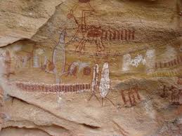
Where most rock art sites in Europe are a single cave or a series of caves in a single mountain, Pedra Furada is a collection of over 900 sites with over 1150 images painted on the walls and ceilings, mostly with red ochre or other clays, and some burned bone charcoal.  The oldest images date from 12,000 years old, the newest about 5,000 years old, showing a change in style over time from fingerwork to paintings created with cactus spines and brushes made of fibers or fur.  They show people hunting with atlatls (dart throwers), dancing, mating, giving birth, and fighting.  Many animal are represented, including caimans, llamas, pumas, deer, capybaras, turtles, fish, and iguanas.

Pedra painting with red deer and humans

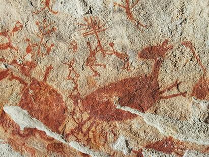
Often the red deer are large, surrounded by small images of people, as in the panel shown. Other sections feature rows of marks and unidentified figures, and what seem to be narrative sequences.

Pedra patterned body


Some large rectangular humanoid figures with patterned bodies are surrounded by smaller human forms with raised arms.


The treasure underfoot

What lay deep in the ground near the painted walls was even more surprising than the paintings.  Guidon and her team spent years carefully excavating the areas, finding evidence of hearth fires and stone tools in layers ranging from 5,000 years old to 32,000 years old, with lower levels dating to 48,000 years old.  Repeated analysis by independent labs, mostly in France, supported those dates.  Guidon herself, never one to shy away from an argument, maintained in a 1985 article in Nature that the site showed clear evidence of human occupation 60,000 years ago!

Clovis First”

Her findings enraged American archaeologists because they challenged the common belief that people arrived in the Americas by walking across the land bridge from Asia, called Beringia, to Alaska during the Ice Age, about 13,000 years ago.  From there, they supposedly dispersed all through the Americas.

Clovis points

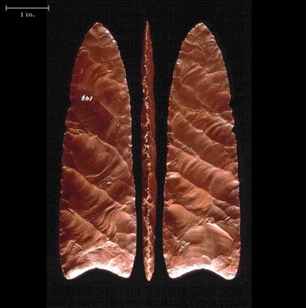
This theory began in the 1930’s with the discovery of a finely-made spear point lodged in a mastodon bone near Clovis, New Mexico.  When other points/arrowheads with this same design were found in neighboring states, and then across the country, archaeologists decided that these points were made by East Asian big game hunters who followed their prey across Beringia and down an ice-free corridor between glaciers into what is now the western United States.  The presence of the Clovis points became the basis for a belief in a Clovis people and a Clovis culture that was so effective it spread from north to south throughout the Americas. The Clovis First theory was repeated endlessly in school textbooks throughout the 20th century.  (The Clovis point in the photo shows the characteristic fine work on both sides (bi-face).

clovis_continent_647kb

There were a few glitches in the theory, but they were largely ignored.  For instance, the greatest concentration of Clovis-style points has been found in the southeastern US, not in Alaska or northern Canada, so we can assume they moved from the east to the west, not the other way around.  (See diagram of Clovis point distribution)

Plus, there was never any proof that the Clovis-style points indicated either a people or a culture.  Today, iPhones are found all over the world, but they represent neither a people nor a culture.  They’re simply a very useful bit of technology.  Probably Clovis points were too.  A valuable trade item, endlessly copied – spreading across the continent.

But all of these problems with “Clovis First” were dismissed by the established powerhouses in American archaeology, especially at Harvard and Yale.

Dennis Stanford, now with the Smithsonian Museum of History, admitted that when he was excavating a site in Florida and came across signs of human habitation far older than Clovis dates, he told his team to fill the pit back in and tell no one about it since their findings would never be accepted.

Who’s she?  

Then along came this brash Brazilian woman with her French education and her crazy theories about early man in Brazil.  The US archaeological community tore her findings apart, claiming the tools were made by monkeys, or they were “geofacts,” natural objects altered by weather or falling to the ground.  In a heated response to a question about them from a reporter from The Guardian,  Guidon said, “US archaeologists believe that the artifacts are geofacts created naturally because the North Americans CANNOT BELIEVE they do not have the oldest site!”  When critics said the carbon hearth samples were the result of natural fires, she pointed out the sites lay well inside caves or rock overhangs, inside circles of stones.  No carbon was found in sample pits dug outside the shelters. “The carbon is not from a natural fire.  It is only found inside the sites.  You don’t get natural fires inside the shelters,” she retorted.  “Americans criticize WITHOUT KNOWING.  The problem is not mine!  The problem is theirs!  Americans should excavate more and write less!”

Guidon challenged American archaeologists to come to the site, draw their own samples, and do their own tests.  They refused.

When they couldn’t make her back down, US archeologists discredited, belittled, then ignored Guidon, her research, and her site. It simply never appeared in surveys of ancient settlements in the Americas.  “Everybody has pretty much deep-sixed Guidon,” one noted American archaeologist commented.

But time, it seems, is on her side.


New finds in Chile and South Carolina

Tom Dillehay, an American archaeologist working at sites in southern and central Chile, found extensive evidence of human habitation there 18,000 years ago, 5,000 years before the supposed appearance of the “Clovis people.”  Settlers on the Chilean coast built lodges, ate a variety of seafood, and used different kinds of seaweed for medicines.  Presence of quartz and tar from other areas indicated either a trade network or a wide area of exploration. Even though Dillehay had painstakingly recorded every discovery and each step of the dating process, and used independent labs for verification, the established archaeological community initially refused to consider his conclusions.  He had to spend ten years defending his findings, but thanks to his persistence, there’s now at least a bit of doubt concerning Clovis First.

Albert Goodyear, who has been working at the Topper Hill chert mine site in South Carolina since the 1980’s, ran into similar problems when he found a rich deposit of Clovis style points and then, much farther down, ran into a completely different set of hearths and tools.  The deepest layers dated to 50,000 years old.  Again, the archaeological community raged against the findings, making life so miserable for Goodyear that he considered leaving the field completely.

For scholars with a vested interest in preserving Clovis First, it simply wasn’t possible that there were settlements before Clovis.  If so, all their work would be meaningless.

Fig 7

Santa Elina rock shelter and more

Then more news came from Brazil, including discoveries at Santa Elina rock shelter in central Brazil, where pierced bone ornaments made from giant sloths (photo) were dated over 23,000 years old.  Like Pedra Furada, it too had rock art and evidence of occasional, seasonal use over thousands of years.  A site in Uruguay yielded evidence of humans hunting giant sloths 32,000 years ago.  Now, these finds are being lumped together with Guidon’s research, indicating a record of human habitation in the area at least 30,000 years old.  Some suggest over 50,000 years old.

Other revelations have followed.  But the most dramatic challenge has come from Steven and Kathleen Holen, who have long held the belief that people were in the Americas before 40,000 years ago.  In a paper in Nature, they argue that break marks on 130,000 year old mastodon bones found in Southern California suggest hominins (ancestors of modern humans) did the butchering using stone tools, perhaps to get at the marrow or use the bones for tools.  To illustrate their point, the Holens used rocks they found at the site to break open elephant bones.

The dust still hasn’t settled from the fracas over their claims.

Even more radical theories

As Niede Guidon said years ago, “I think it’s wrong that everyone came running across Bering chasing mammoths – that’s infantile.  I think they also came along the seas.”  Now in her 80’s and mostly retired, she hasn’t softened her tone at all.  She currently maintains that people first arrived in South America from West Africa, perhaps as far back as 100,000 years ago.

kayaker1-300

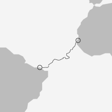
She says they could have floated or paddled across the sea with the current and the wind in their favor.  Both journeys have been replicated in modern times.  (The diagram at the left shows the route a 70-year-old Polish kayaker took in his solo journey across the Atlantic in 2017.)  If you look at the globe, an African origin certainly makes more sense for settlements in northeastern Brazil than having people go through Alaska, down the coast of North America and Central America, then across the Andes and the Amazon Basin to get to Pedra Furada.Pedra map

But Guidon isn’t stopping there.  She suggests that the group from Africa may have merged with groups from the South Pacific that came by sea, settled on the Pacific coast and later crossed lower South America.

Evidence for the South Pacific theory    Botocudo man, South American natives of eastern Brazil, historical portrait, 1875

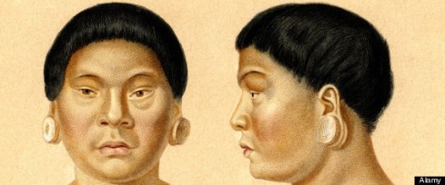
Several native populations in South America were completely eradicated by the Spanish and Portuguese conquerors.  One group, the Botocudo, were murdered by the Portuguese because they wouldn’t submit to enslavement.  Oddly, the Portuguese kept several of the skulls, which later wound up in a museum.  When modern scientists drilled into the teeth and tested the DNA, they found markers typical of Polynesians and Australians. (Drawings of a Botocudo man, above).  See earlier post on “Chickens, Sweet Potatoes, and Polynesians in Brazil.”

The Long Chronology

Increasingly, it looks as if there is no one simple answer to the origin or timeline of the peopling of the Americas.  A new theory, called the Long Chronology, posits multiple waves of immigrants from different places arriving over a long period of time, probably with only a few successful, surviving settlements.  This pattern seems more promising than Clovis First – and certainly more defensible given new discoveries.  This does not rule out migration from Siberia or along the west coast of North America.  It simply takes away its claim of exclusivity.

Serra da Capivara

Pedra Serra da Capivara entrance

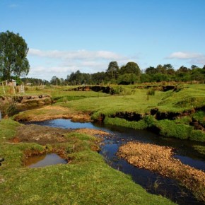
Meanwhile, Niede Guidon is busy trying to get funding to keep the 320,000 acre national park she fought for, now called Serra da Capivara, open. (Entrance shown in photo.)  Her research helped establish it as a UNESCO World Heritage Site in 1991, but government support is undependable.  Few American archaeologists have ever visited.  Only the hardiest tourists make the trip.  But Guidon’s work is finally getting some attention from the press and the academic world.  Robson Bonnichsen, from the University of Maine’s Center for the Study of the First Americans, feels her work needs more attention.  “We’re trying to get some eminent American scholars down there to study the methods and results,” he said.  He plans to lead the first American excavation team there.

This should be interesting to watch.  Perhaps if an American man gets the same results, the data will get more respect.  If so, Guidon will probably wonder what took the rest of the world so long to catch up with her.


Sources and interesting reading:

Bellos, Alex, “Archaeologists feud over oldest Americans, The Guardian, 10 February 2000, https://www.theguardian.com/science/2000/feb/11/archaeology.internationalnews

Bower, Bruce, “People may have lived in razil more than 20,000 years ago,” Science News, 5 September 2017, https://www.sciencenews.org/blog/science-ticker/stone-age-people-brazil-20000-years-ago

Bower, Bruce, “Texas toolmakers add to the debate over who the first Americans were,” Science News, 11 July 2018, https://www.sciencenews.org/article/texas-toolmakers-add-debate-over-who-first-americans-were

Brooke, James, “Ancient Find, But How Ancient?” 17 April 1990, The New York Times, https://www.nytimes.com/1990/04/17/science/ancient-find-but-how-ancient.html

Fenton, Bruce, “Brazilian rock shelter proves inhabited Americas 23,000 years ago” The Vintage News, 29 January 2018, https://www.thevintagenews.com/2018/01/29/brazilian-rock-shelter/

Guidon, Niede, “Nature and the age of the depostis in Pedra Furada, Brazil: Reply to Meltzer, Adovasio and others, Antiquity, vol.68, 1994. https://www.researchgate.net/publication/285362399_Nature-and-age_of_the_depostis_in_Pedra_Furada_Brazil…

“Interview with Niede Guidon,” Crosscultural Maria-Brazil, http://www.maria-brazil.org/niede-guidon.htm

Jansen, Roberta, “The archaeologist who fights to preserve the vestiges of the first men of the Americas,” BBC News, 12 March 2016, https://www.bbc.com/portuguese/noticias/2016/03/160312_perfil_niede_guidon_rj_ab

“Niede Guidon,” Wikipedia, https://en.eikipedia.org/wiki/NI%C3%A8de_Guidon

“Niede Guidon,” WikiVividly, https://wikivividly.com/wiki/Niede_guidon

“Pedra Furada,” Britannica Online Encyclopedia, https://www.britannica.com/place/Pedra-Furada

“Pedra Furada,” Wikipedia, https://en.wikipedia.org/wiki/Pedra_Furada

“Pedra Furada, Brazil: Paleoindians, Paintings, and Paradoxes, an interview with Niede Guidon and others, Athena Review, vol. 3, no.2: Peopling of the Americas,

Peron, Roberto, “Pedra Furada the Pierce Rock Site,” Peron Rants (blog) 28 April 2017, https://rperon1017blog.wordpress.com/2017/04/28/pedra-furada/

Powledge, Tabitha, “News about ancient humanity: Humans in California 130,000 years ago?” PLOS Blogs, 5 May 2017, http://blogs.plos.org/onscience blogs/2017/05/05/news-about-ancient-humanity-humans-in-California-130000-years ago…

“The Rock Art of Pedra Furada,” The Bradshaw Foundation, http://www.bradshawfoundation.com/south_america/serra_da_capivara/pedra_furada/index.php

Rock Art panel, photo by Diego Rego Monteiro – Own work, CC BY-SA 4.0, https://commons.wikimedia.org/w/index.php?curid=43861884

Romero, Simon, “Discoveries Challenge Beliefs on Humans’ Arrival in the Americas,” The New York Times, 27 March 2015, https://www.nytimes.com/2014/03/28/world/americas/discoveries-challenge-beliefs-on-humans-arrival-in-the-americas.html

“Serra da Capivara National Park,” Wikipedia, https://en.wikipedia.org/wiki/Serra_da_Capivara_National_Park

Wade, Lizzie, “Traces of some of South America’s earliest people found under ancient dirt pyramid,” Science, 24 May 2017, http://www.sciencemag.org/news/2017/05/traces-some-south-america-s-earliest-people-found-under-ancient-dirt-pyramid

Wilford, John Noble, “Doubts Cast on Report of Earliest Americans,” The New York Times, 14 February 1995, https://www.nytimes.com/1995/02/14/science/doubts-cast-on-report-of-earliest-americans.html


Monte Verde Mysteries

Monte Verde is an archaeological site in southern Chile, currently situated some 35 miles (45 kilometers) east of the Pacific coast on Chinchihuapi Creek. It doesn’t look extraordinary, but discoveries made on both sides of this little creek are shaking up the archaeological world. After twenty years of challenges from doubting archaeologists, especially those supporting the Clovis First theory, the evidence from Monte Verde still supports the thesis that this site was occupied by humans at least 14,800 years ago, which makes it the oldest widely accepted site of human habitation in the Americas.

Monte Verde siteMonte Verde map

The site, incredibly well-preserved by a bog, challenges many – make that almost all – of our preconceptions about ancient explorers in the Americas. And it raises many questions without easy answers.


Question 1

Is the site 14 ,800 years old – or more than twice that old?

The oldest human habitation date that archaeologist and anthropologist Tom Dillehay suggested – and subsequently defended against loud criticism from fellow American archaeologists – was 14,800 years ago, the date he and his colleague, geologist Mario Pino, connected with the bottom layer of the first excavation. In this area, they found stone artifacts including points, bola stones, and a drill, the remains of wood frame structures apparently covered in hides and floored with rough planks, ropes and knots, two large fire pits, animal bones and fur, remains of tubers, seeds, nuts, berries, mushrooms, seaweed, algae, and leaves. The finds included 15 species of aquatic plants and 45 other plant species. It was an extraordinary discovery.

But it was complicated by an even more extraordinary find just the other side of the creek, where Dillehay and Pino found stone tools and evidence of hearths that were over 30,000 years old. Dillehay knew that 14,800 year old date would be extremely controversial, so he chose to effectively ignore the earlier finds.

Pino and Dillehay(Pino, left, and Dillehay, right, in photo)

“I don’t yet see any reason to believe people were in the Americas and that far south 30,000 years ago,” Dillehay remarked. In his report, he acknowledged the presence of the stone tools and carbon scatters consistent with hearths but refused to make the much earlier claim.

Mario Pino, on the other hand, did make the claim. So how old is Monte Verde? “There’s no doubt about the age – it’s 33,000 years old,” Pino said in a New York Times article in which he noted the age of the sediment layers bearing the apparent artifacts.

Now that most of the archaeological powers that be have reviewed the evidence of the first site and grudgingly accepted it, opinions are softening somewhat toward the older site. “We’ll open up that level and see what’s there,” Dillehay said in a more recent interview.

So Monte Verde is 33,000 years old – maybe, or 14,800 years old – probably – at least.


Question 2

What does the variety of food and medicine found at Monte Verde say about the people?

MV close-up map

Mastodon bones sticking out of a washed out riverbank first drew attention to the Monte Verde site. Experts estimate the animal that went with the tusk fragment weighed two tons. Finds also included a chunk of mastodon meat, remains of llama, shellfish, fish, small mammals, edible seeds, mushrooms, tubers, berries, stalks, and wild potatoes. In all, remains of 45 different plant species were found on site, over 20% of them originating over 150 miles away. Some of the plants came from the coast – 56 miles (90 km) to the west back then; others from marshes, forests, and arid grasslands. So either the people gathered food from very distant sources and brought it back to their village or they engaged in trade with other people in other locations. In either case, these people understood seasonal availability and enjoyed a varied diet.

And about all that seaweed …

At least nine different species of seaweed, both edible and medicinal, were originally found at the site. Later exploration of the site provided evidence of many more. Dillehay’s 2008 Nature paper indicates they found 19 seaweed species, five of which came from the coast. The following list includes some of the seaweed species discovered at the site, all of which are still used as a good source of minerals and protein, fertilizer, wound dressing, and medicine:


Durvillaea – a large kelp (“bull kelp”) found between Chile and Antarctica that is able to float because of air held within its honeycomb blades. It forms large rafts that can cross the open sea. It provides essential minerals and acts as an antioxidant. Currently, it’s used to promote heart and kidney health and to slow cellular degeneration associated with aging.

Porphyra – red/black algae from the south and west, edible. Called nori in Japan, it’s commonly used to wrap sushi. In Asian medicine, it’s combined with other seaweed species to treat goiter, cysts, tumors, lymph node swelling, liver and spleen enlargement. It’s currently the most valuable marine crop in Asia, worth over $1billion dollars.

Mazzaella – edible red, iridescent seaweed from the coast, currently used as a thickening agent and a commercial fertilizer

Sarcothalia (Luga negra) – currently harvested off the coast of Chile. David Horgen of Hawaii Pacific University is studying the ability of waixenicin A, a compound in Sarcothalia, to fight cancer.

The four species listed above are from west and south of Monte Verde.


Garcilaria – seaweed found in near shore tide pools and reef flats, believed have come from the Philippines and Hawaii, a sea vegetable with anti-viral qualities, currently used to fight herpes and HIV

Gigartina – near shore seaweed used as a sea vegetable. In medicine, it’s used as an anti-viral and immune booster, helpful in controlling skin lesions, herpes, and other infections.

The two species listed above come from the coast.

Currently, Gracilaria, Sarcothalia, Gigartina, and Porphyra are considered four of the most important seaweed species Chile harvests and sells. They’re used in the production of food and medicine, as well as fertilizers and filters.

MV giant kelp

Macrocystis – giant kelp, (photo left), an incredibly fast growing plant of cooler waters along the coast of North and South America, South Africa, New Zealand, and Australia. The plant’s long stalk, up to 160’ tall, is held up by a gas bladder. Large stands form kelp forests that support a wide range of wildlife. Rich in iodine and potassium, it’s long been used as a food source and wound dressing.

This seaweed grows offshore.

Sargassum – a seaweed originating in Japan, capable of surviving in a variety of habitats, including open water. Sargassum forms large floating mats at sea, which may explain how the species has successfully invaded shore areas around the world. Medicinally, it’s useful for treating goiter, tumor, pain, and swelling.


Sargassum is most commonly found in open water, not by the shore. Interestingly, most of these seaweeds come from the south and west of Monte Verde. Both Sargassum and Durvillaea form large floating mats that can cross open water. (photo, below)

Lines_of_Sargassum

Trentepohlia – a green alga (often appearing orange) that grows on tree trunks, buildings, and shore rocks. Recent research has shown it to be a powerful anti-microbial agent against five species of bacteria and five species of fungi, including agents of human, animal, and plant diseases, mycotoxin producers, and food spoilage agents.

What an interesting combination of plants! It seems we’re just now catching up with our relatives from long-ago in understanding their value.

The “cuds”

While it’s impossible to infer their uses for all of these, we can be fairly sure they used some as medicine because of the “cuds” found at the site – partially chewed mixtures of plants still bearing the mark of the chewer’s upper palate.

These “cuds” suggest the people of Monte Verde were familiar with properties of different seaweed species.   In addition, they went great distances and faced considerable difficulties of harvesting coastal and open water species. “This is suggestive of a fairly sophisticated knowledge of coastal ecosystems,” Dillehay remarked.

Or perhaps they traded with others who lived on the coast. Presence of material not found locally, such as quartz and tar, support the idea of a trade network. In 2007, the discovery of another site nearby, Pilauco Bajo, led to the theory that the two sites were associated. If Monte Verde was part of a trade network, it must have been the southern terminus. During the Ice Age, glaciers covered the southern tip of South America.


Question 3 – Where did the residents of Monte Verde come from?

This question brings up lots of other questions and even more arguments.

The Land Bridge Route

 paleomigration map

The most common theory of migration into the Americas involves the Land Bridge from Asia known as Beringia. According to this theory, the first people in the Americas walked across from Siberia to Alaska, following big game. From there, they found their way south and east through an ice-free corridor that opened up between mile-high ice sheets around 13,000 years ago. (Red line in map)

But see there’s a problem now, if a site in southern Chile is older than the ice-free corridor. Actually, the Beringia theory is so widely accepted that some archaeologists declared the Monte Verde dates to be impossible because they came before the Beringia dates.


The Coastal Route (pink line on map)

Then another theory surfaced – the coastal route. Harvard archaeologist Carol Mandryk said the ice-free corridor idea through Canada wouldn’t work because even after the ice sheets began to melt 13,000 years ago, vegetation would have been too scarce to support big game. Instead, she said, people came down the coast in small boats. In this case, people came from Asia but rather than walking, they took the sea route, hugging the edge of the coast and ice, until they reached what’s now Oregon, which was ice-free. From there, people populated the rest of the Americas.

But at 14,800 years old, Monte Verde predates the known sites in Oregon. Well, some argued, rising sea levels had covered all evidence of earlier passage. Or the bands of people were so small, they left no trace. They were “archaeologically invisible.”


The Kelp Highway

Proponents of the Kelp Highway hypothesis say that early explorers traveled by boat from Asia to South America following the kelp beds. This would explain the knowledge of different seaweed species, especially giant kelp, found at the Monte Verde site. However, giant kelp, Macrocystis, is typically found in open water rather than shallow coastal waters. “It was blown ashore in storms,” proponents explain.

MV Solutrean

The Solutrean Solution

Dr. Dennis Stanford, head of Archaeology of the National Museum of Natural History, the Smithsonian, a former Clovis Firster, changed his mind and came up with what’s been called the Solutrean Solution, claiming that people from northern Spain/southern France brought advanced technologies like weaving, sewing, painting, atlatls, and stone work across the North Atlantic by taking boats north from Europe toward Greenland and then south, hugging the shore/ice until they reached modern-day southeastern USA. This Solutrean stonework then turned into the famous Clovis points that spread east to west across the continent with trade. (Solutrean path is marked in red on map)

An interesting theory – with many critics. However, in order for those people to reach Monte Verde, they would have had to go the length of the Americas and around the tip of South America to the west side, during the Ice Age, when the Patagonian ice sheet covered the whole area.

MV mysterious Pedra Furada art

The West from Africa Route – The Pedra Furada Dilemma

Pedra Furada is actually a large cluster of sites in the Serra de Capivara Park near the northeast coast of Brazil. Its presence, and the tenacity of its principal investigator, Niede Guidon, have become a serious problem for the Clovis/Beringia theorists. Pedra Furada sites have consistently returned dates of 32,000 to 48,000 years ago. Since these did not fit with the Beringia theory, archaeologists from the US, in a terrible example of academic blindness and resentment, refused to consider it.

Pedra Furada

One look at Pedra Furada on a globe will show the closest land mass is – West Africa, not Asia. But this migration route would involve open water travel, which archaeologists seem reluctant to believe despite the evidence that people traveled over open water to Australia in an even earlier time period. Ocean currents and prevailing winds would take a boat traveler from West Africa directly to South America. Now a few maps include a west from Africa route, but not many.

But even the West Africa Route would not explain Monte Verde. The Andes stand in the way.


The South Pacific Route

If Monte Verde is indeed 33,000 years old, and the oldest date in North America is 20,000 younger, it seems to indicate some other migration route: across the South Pacific. This would explain the knowledge of open ocean seaweeds. Ocean currents would take people from the Pacific Islands south and then swing north as they neared South America. (Southernmost route marked on map)

Multiple routes map


Actually, a shocking discovery points exactly there.

According to a paper published in the journal Nature, April 2013, Polynesian DNA has been found in ancient Native American bones.

Molecular geneticist Sergio Pena analyzed DNA from teeth in skulls of Botocudo, indigenous people who lived in southeastern Brazil until they were eradicated by the Portuguese in the 1800s in an attempt to quell dissent.


Botocudo man, South American natives of eastern Brazil, historical portrait, 1875

(The drawing included here is a portrait of a Botocudo man made in 1875.)  Fourteen Botocudo skulls were kept in a museum in Rio de Janeiro.  To the scientists’ surprise, in two of the skulls, they found DNA indicating Polynesian ancestry.  A second lab confirmed the findings.  Pena remarked, “The most exciting potential explanation of the DNA findings is that ancestors of the Botocudo once interbred with those of Polynesians before the peopling of the Americas 15,000 – 20,000 years ago.  Prior studies of skull shapes hinted that two distinct groups entered the Americas – one more Asian type seen now in the vast majority of extant Native Americas, and an earlier type seen in skeletons in Brazil and elsewhere that resembled some African groups, Australians, Melanesians, and Polynesians such as Easter Islanders.”

Loud debate erupted as soon as the news was released.  Yet one of the most interesting parts of the discovery went unnoticed.  DNA studies, on which we currently base our models of human colonization of the Americas, were – up until this study – based almost exclusively on living people.  Thus any race that went extinct, such as the Botocudo and many others, would never be represented and their part of the story never told.

Easter Islanders have Polynesian DNA. Apparently Polynesian navigators found a small island about 2618 miles (4229 KM) from Tahiti. If ancient navigators could take on open ocean voyages to Easter Island, they could probably find a continent.

Response

And yet, here’s the official response: “No scholars seriously consider the possibility that the early Americans landed first in South America. All linguistic, genetic and other evidence points to the Bering Strait as the most likely point of entry” (John Nobel Wilford). “No archaeologists seriously consider the possibility that the first Americans came by sea and landed first in South America.” (Charlie Hatchett).

Well, perhaps they should. And while they’re at it, perhaps they should consider the antiquity of sites in Pennsylvania, Texas, and South Carolina which predate sites on the west coast. Perhaps they should abandon their strange allegiance to a theory that has proven desperately incomplete on so many fronts.


What if the answer is many answers?

Evidence from Pedra Furada, Monte Verde, Topper Hill, Paisley Caves, Cactus Hill, and other sites points to multiple points of entry into the Americas, at different times.  If so, the diagram would look something like the one above.  Actually, it might have a lot more arrows on it.

Monte Verde gives us a new and very different view of early visitors to the Americas. Perhaps further research will answer some of the thorny questions Monte Verde has posed.


Sources and interesting reading:

Avila, Marcela, and others, “Economic feasibility of Sarcothalia cultivation” Hydrobiologia 16th International Seaweed Symposium, 1999.

Buschmann, Alejandro H. and others, “Seaweed cultivation, product development and integrated aquaculture studies in Chile,” World Aquaculture, (36) September 2005

Curry, Andrew. “Ancient migration”: Coming to America, Nature news feature, 2 May 2012, http://www.nature.com/news/ancient-migrations-coming-to-America-1.10562

Dillehay, Tom D. and others, “Monte Verde: Seaweed, Food, Medicine, and the Peopling of South America,” Science, 9 May 2008 (320) 764-786, http://www.sciencemag.org/content/320/5877/784. Or http://www.ncbi.nlm.nnih.gov/pubmed/18467586

“Durvillaea Antarctica,” Seaweed Industry Association, http://seaweedindustry.com/seaweed/type/durvillaea-antaractica

“Durvillaea Antarctica,” Wikipedia, http://en.wikipedia.org/wiki/Durvillaea_antarctica

“Edible seaweed,” Wikipedia, http://en.wikipedia.org/wiki/Edible_seaweed

“Evaluation of In Vitro Antioxidant and Antimicrobial Activities of Green Microalgae Trentepohlia umbrina,” ScienceAlerts.com http://sciencealerts.com/stories/2065293/

“Gracilaria,” Invasive Algae Database, http://www.bishopmuseum.org/algae/results3.asp

Hames, Raymond. “Chilean Field Yields New Clues to Peopling of Americas, New York Times, 25 August 1998, http://www.unl.edu/rhames/monte_verde/monte_verde1.htm

Hatchett, Charlie, “Monte Verde Excavation: or Clovis Police Beat a Retreat,” Archaeology Fieldwork.com, http://www.archaeologyfieldwork.com/afe/message/topic/2830/discussion/monte-verde

Hirst, Kris, “Monte Verde Photo Essay: Seaweed Exploitation at Monte Verde II”   About.com Archaeology, http://archaeology.about.com/od/preclovissites/ss/monte_verde_4.htm

Hirst, Kris. “Pacific Coast Migration Model” About.com Archaeology, http://archaeology.about.com/od/

Hirst, Kris. “Kelp Highway Hypothesis: A variation on the Pacific coast migration model of colonizing America,” About.com Archaeology http://arcgaeology.about.com/od/kterms/pt/kelp_highway.htm

Lovgren, Stefan, Earliest Known American Settlers Harvested Seaweed,” National Geographic News, http://news.nationalgeographic.com/news/pf/15550150.html

“Macrocystis,” Natural History Museum, http://nhm.ac.uk/nature-online/species-of-the-day/biodiversity/climate-change/macrocystis

“Monte Verde Archaeological Site, UNESCO World Heritage Center, http://whc.unesco.org/

“Medicinal Uses,” The Seaweed Site: information on marine algae, http://www.seaweed.ie/uses_general/medicinal uses.php

“Monte Verde Archaeological Site,” UNESCO World Heritage Centre, http://whc.unesco.org/

“Monte Verde,” Wikipedia, http://en.wikipedia.org/wiki/Monte_Verde

Oppenheimer, Stephen. “Archaeological Evidence in South America that humans crossed into the Americas before the Ice Age,” The Bradshaw Foundation, http://www.bradshawfoundation.com/journey/clovis-text.html

“Pedra Furada sites,” Wikipedia http://en.wikipedia.org/wiki/Pedra_Furada_sites

Rose, Mark. “The Importance of Monte Verde,” Archaeology, 18 October 1999 http://archive.archaeology.org/online/feautres/clovis/rose1.html

“Sargassum muticum, Wireweed,” The Seaweed Site: information on marine algae, maintained by M.D. Guiry, 2000 – 2014.

“Sargassum,” Wilipedia http://en.wikipedia.org/wiki/Sargassum

“Science dean continues research at National Cancer Institute-designated facility,” Hawaii Pacific University News, March 2013 http://www.hpu.edu/HPUNews/2013/03

“Seaweed confirms Monte Verde dates, but also migration patterns?” Geotimes, July 2008, http://geotimes.org/july08/

Swaminathan, Nikhil, “America, in the Beginning,” Archaeology, Secptember/October 2014, 22-29


Ancient Navigators

Did ancient explorers cross oceans to reach the New World?

Many popular theories explaining the peopling of the Americas, including Clovis First (See earlier post on the Clovis theory) claim that people first arrived in the Americas by walking across Beringia, the Ice Age land bridge from Siberia to Alaska  around 13,000 years ago.  From there they eventually spread overland all the way across and down the Americas.

Monte Verde

Mario Piño, from Chile, and Tom Dillehay, from the USA, provided the best challenge to the Clovis-first theory with their work on the Monte Verde site in Chile (See map).  In 1977, they published their findings, which included evidence of human presence at the site 14,200 years ago.  The upper level yielded interesting finds, including the remains of 20’ long structures made of walls of poles covered with animal hides, large hearths lined with clay, coprolites containing remnants of 45 different plant species including nine species of seaweed, seeds, nuts, berries, remains of local animals, and wild potatoes.  Some of their food came from 150 miles away, indicating either a large gathering area or a functioning food network.

In 1997, the Monte Verde dates were rechecked and confirmed by previously doubting archaeologists, some of whom were forced to admit they might need a more complex answer to the question of how people arrived in the Americas.

However, that wasn’t the real shocker.  Tom Dillehay knew more than he said in his published paper.  He and Piño had excavated a lower level with dates Dillehay knew would never be accepted, so he ignored the lower level in his paper, except to note “although the stratigraphy is intact, the radiocarbon dates are valid, and the human artifacts are genuine, I hesitate to accept this older level without more evidence and without sites of comparable age elsewhere in the Americas.”  Later, he admitted he had found “charcoal scatters which may be the remnants of fireplaces next to possible stone and wood artifacts, and these were dated to at least 33,000BC.”

Mario Piño had fewer reservations.  He asserted the 35,000 years ago date based on his finds at Monte Verde and corresponding dates from an animal bone found at another archaeological site 120 miles north.

Pedra Furado

Another pivotal discovery was made in South America at a site called Pedra Furado in eastern Brazil.  Here, the dates were so revolutionary that few American archaeologists accepted them. In 1986, a woman named Niede Guidon published a paper claiming she had discovered the oldest known site of human habitation in the Americas (at least 33,000 years ago; some dates range from 41,000 to 56,000 years ago).  Included in the strata dated 32,000 years old were fragments of pottery and rock art figures.

Not only did this find challenge the cherished view that the first people to visit the Americas came across the land bridge from Asia into North America 13,000 years ago and then populated the Americas; it blew it out of the water by 20,000 years!  And in South America!  And discovered by a woman!

Even more shocking was the level of sophistication of the very early explorers, with pottery and art.  Its location on the east side of Brazil was also troubling.  If the first people in the Americas came across the Bering Strait, getting to eastern Brazil would mean a sea journey of 10,000 miles down the west coast of the Americas, followed by an incredibly difficult overland journey of thousands more to reach the Pedra Furada sites.  Even some Clovis-Firsters thought it seemed far more plausible that the early explorers in Brazil came from Africa, making a trans-Atlantic journey of about 2000 miles, with both currents and wind in their favor.  (In 2012, Katie Spotz, a 22-year old woman, rowed her way from West Africa to South America, solo, in 70 days.)

More recent finds at the Meadowcroft Rock Shelter in Pennsylvania have been dated to 14,250 years ago, pre-dating the Clovis sites by a thousand years.  Other ancient sites in Delaware and Virginia have again raised the possibility that ancient explorers crossed the Atlantic Ocean long before Leif Erickson and Saint Brendan did.

The problem, it seems to me, is underestimating both the intelligence and the navigational skill of the ancient explorers.

Amazing explorers

Homo floresiensis, the “Hobbit” people whose remains were found on Flores Island in eastern Indonesia, lived from 94,000 to 12,000 years ago.  The oldest bone fragment unearthed at the dig site was dated to 74,000 years ago.  People settled in Australia at least 45,000 years ago, though some claim the date is more than 60,000 years ago.  In order to reach these places, even with the ocean levels much lower than they are today, people needed to use boats.

Ancient Polynesian navigators, the greatest open ocean explorers in the world, found their way from Indonesia and New Guinea out into the Pacific Ocean, covering an area larger than North and South America combined, including Fiji, Hawaii, and Easter Island.  (DNA studies have shown the Easter Islanders to be Polynesian.) It’s 4,610 miles from Fiji to Easter Island.  Many believe that the Polynesians went on from Easter Island to explore the west coast of South America, (only 2,400 miles farther) bringing chickens from Asia to the New World and taking sweet potatoes back with them to Easter Island and Polynesia.

When European explorers arrived in Polynesia, they were amazed that the native mariners regularly sailed far out of sight of land and returned safely, maintaining a wide-area trade system that linked over a hundred islands, all without use of maps, compass, or sextant.

Later colonizers refused to believe these “savages” could be so skillful, dismissing their claims as fiction.  In the 20th century, when the old ways of the navigator had almost disappeared, some Western sailors decided to learn the ways of the native navigators.  The most famous was David Lewis, an accomplished sailor whose book We, the Navigators: The Ancient Art of Landfinding in the Pacific became the best source of information on the fading art of the South Pacific navigator.  The 13,000 miles he sailed with native navigators in the South Pacific showed him how amazingly accurate their methods were.  On some of the early voyages, he kept a compass and charts locked away in case he needed them.  He didn’t.

Steering by the Stars

A traditional Polynesian navigator needs to know the night sky so well that he can mentally see the whole sky even if most of it is obscured by clouds.  (I’m using he because all of the traditional Polynesian navigators still alive are male, and instruction in the art is now limited to males.  However, ancient pictographs of Polynesian explorers show men, women, and children on board, in addition to lots of plants, even trees, and animals.)

He needs to memorize the exact path, including rising and setting points, of at least 36 major stars and over a hundred secondary ones.  For example, some stars rise in the east, such as Altair, the brightest star in our constellation Aquila the Eagle, and arc toward the north, so they can be used as reliable indicators of east only for a short time after they rise, a period usually measured in fists.  The navigator holds out his arm so his fist lies between the horizon and the star he’s using.  He knows this particular star is only reliable until it reaches two fists above the horizon.  After that, he needs a new star to take him to the east.  It might be a new star rising in the east or a star like Spica, which sets directly west. Navigators who travel to particular islands regularly know a sequence of stars to follow to each destination.  The star compass pictured includes many of the stars navigators would know though they were known by different names in different areas.  This knowledge was carried in the navigator’s memory, not on paper.

If the eastern part of the sky is obscured by clouds, he must be able to use whatever part of the sky he can see to give him the orientation he needs to fill in the rest of the sky.  Absolutely accurately.

Pictured above is the Universal Star Compass, from The Barefoot Navigator.

Currents

He also needs to read the pattern and direction of the waves passing under the flexible hulls of his boat.  Ocean currents in Polynesia tend to be very consistent.  As the long waves pass under the boat at a consistent angle, the navigator knows where the currents are coming from and judges his direction accordingly.  He knows that the currents bend and shorten as they near land.  If storms are coming in, the surface currents will be different from the deeper currents. In some cases, he has six or seven different currents to track.  Some navigators lie down on the deck or the outrigger to get an exact reading of the multiple currents.

The stick chart pictured shows the currents in a particular area.  Islands are marked with shells.  While navigators sometimes studied charts like this before a voyage, they were not typically brought along on the boat.  Few navigators explained the charts to outsiders.

Birds, Vegetation Mats, Clouds, Colors, Smells

The traditional navigator knows that while certain birds are trans-oceanic flyers, like the albatross, others serve as good indicators of nearby land. Terns and noddies fly out from land in the morning and return at night.  Frigate birds released from their cages are another good indicator of land.  Since the birds will drown if they get their wings wet, they will either fly toward nearby land or head back to the boat.

The migration of the Pacific golden plover was said to inspire the ancient Polynesians in Tahiti to look for the land the plovers were heading toward, which turned out to be the Hawaiian Islands.  Later, Captain Cook also used the migration of the plover as an indication that land lay to the north, which is how he found Hawaii in the middle of the ocean.  The golden plover, kolea, appears on the Hawaii state stamp (pictured) and on petroglyphs on Hawaii (illustration). 

Mats of vegetation are also reliable indications that land is fairly close.  Farther away, the mats break up due to wave action.  The navigator looks to the clouds for information on wind velocity and approaching weather.   In addition, clouds tend to form over land due to transpiration, so a lone cloud on the horizon might indicate an island lies beneath it.   Sky color is also important, as is the color of the water, paler over reefs or submerged islands, darker in very deep sections.

A traditional Polynesian navigator had to use his entire body as a sensor.  It’s no wonder the ancients respected him.

A Polynesian Network

Upon discovering the remains of a reed boat and wild sweet potatoes on Easter Island, Thor Heyerdahl theorized that South Americans drifted with the western current to Easter Island, bringing both the boat and the sweet potato with them, then later drifted all the way to Polynesia.  While this theory has since been discarded, it may be partially correct.  If the Polynesians went east all the way to South America, they may well have made the round-trip, bringing chickens to South America and the sweet potato to Easter Island.

Another fascinating hint at a Polynesian network comes from a Peruvian mummy examined by the University of York’s Mummy Research Group.  They found it had been embalmed with the resin of the Araucaria conifer, closely related to the Monkey Puzzle Tree found in New Guinea.

The Importance of the Sea Explorer Community

Exploration by sea may have played a very important role in the development of human society.  It necessitated an exact and widespread language, a desire to act together for the common good, advanced tool use, engineering skill, and extensive knowledge of the natural environment.  It would have been driven by a need for constant innovation: stronger, flexible hulls, a more complete star map, different sail, hull, and paddle designs, double masts, outriggers.  Knowledge was power.  The person who could take a boat out of sight of land and return again was recognized as special.  The person who could manage the same feat by night was very special.  If he could manage a voyage of many days and nights between distant islands, he was extraordinary.   Sea exploration created a society made of an accepted leader and his followers.  The navigator’s word was law, just as it is today onboard a ship.  Once the explorers formed a settlement in the new land, it would have been natural to maintain this social order, at least until populations grew and resources became scarce.

The ancient navigators faced a world ready to kill them if they were stupid or careless, maybe even if they weren’t.  They accepted life that way.  Sometimes I think it’s sad that so many people hunger for that kind of adventure today and find it only inside a video game.

Sources and interesting reading:

Guidon, N. and B. Arnaud. “The chronology of the New World: Two Faces of One Reality,” Ecole des Hautes Etudes en Sciences, Sociales, Paris

Guidon, N. and Delbrios, G. 1986 “Carbon 14 dates point to man in Americas 32,000 years ago,” Nature, 321:769-771.

Gladwin, Thomas.  East Is a Big Bird: Navigation and Logic on Puluwat Atoll. Cambridge, Massachusetts: Harvard University Press, 1970.

“Homo Floresiensis,” Wikipedia

Lagan, Jack.  The Barefoot Navigator: Navigating with the skills of the ancients.  Dobbs Ferry, New York: Sheridan House, 2005.

Lewis, David.  We, the Navigators: The Ancient Art of Landfinding in the Pacific, second edition. Honolulu: University of Hawaii Press, 1994 (an excellent source)

“Monte Verde,” Wikipedia

“New Evidence from Earliest Known Human Settlement in the Americas,” Science Daily.  www.sciencedaily.com

“Pedra Furada, Brazil: Paleoindians, Painting, and Paradoxes,” Athena Review, vol. 3, no. 2: Peopling of the Americas. www.athenapub.com/10furad.htm.

“Pedra Furada sites, (Piaui, Brazil)” by George Weber, www.andaman.org/BOOK/chapter 54

“Polynesian Discovery,” History channel, available on YouTube

“Sailing by the Stars – How the Ancients Did It” sailboat2adventure.com.blogspot.com

Schmitz, P. I. 1987. “Prehistoric hunters and gatherers of Brazil.” Journal of World Prehistory, 1:53 – 126.